The Geology of Wonder: How Phang Nga Bay’s Towering Karsts Were Born
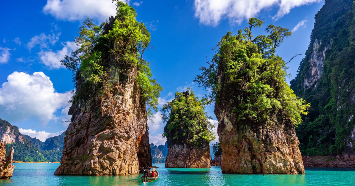
As your kayak glides between the towering limestone pillars of Phang Nga Bay, you’re witnessing one of Earth’s most spectacular geological masterpieces—a landscape so extraordinary that it seems almost impossible. These vertical limestone towers, rising like ancient skyscrapers from emerald waters, tell a story that spans hundreds of millions of years and involves forces so vast that they shaped entire continents.
For over three decades, Andaman Sea Kayak guides have been sharing not just the beauty of these karst formations, but the incredible scientific story of their creation. Understanding the geology behind Phang Nga Bay’s towers transforms every paddle stroke into a journey through deep time, where visitors can witness the results of processes that began when the first complex life forms were evolving in ancient seas.
This is the epic story of how Phang Nga Bay’s karsts were born—a tale of ancient oceans, massive tectonic collisions, patient chemical weathering, and the relentless power of water to sculpt stone into architectural wonders that surpass any human construction.

Chapter 1: The Ancient Ocean Floor (280-250 Million Years Ago)
When Thailand Was Underwater
The story of Phang Nga Bay begins in the Permian Period, roughly 280 million years ago, when this region lay beneath a vast tropical ocean called the Tethys Sea. At this time, the area that would become Thailand was positioned much closer to the equator, experiencing warm tropical conditions perfect for marine life to flourish.
The Permian Ocean World:
- Water temperature: 25-30°C year-round (similar to modern Caribbean)
- Ocean depth: 50-200 meters (shallow tropical seas)
- Marine life: Dominated by coral reefs, brachiopods, and early marine reptiles
- Atmospheric conditions: High CO2 levels creating greenhouse conditions
- Continental position: Part of the supercontinent Pangaea’s eastern edge
This ancient ocean teemed with life forms that would become the building blocks of Phang Nga Bay’s limestone foundations. Countless trillions of marine organisms—from microscopic foraminifera to massive coral colonies—lived, died, and settled on the ocean floor over millions of years.
The Great Limestone Factory
The formation of what would become Phang Nga Bay’s karst landscape began with one of nature’s most efficient construction processes: biological limestone production. Marine organisms extracted calcium carbonate from seawater to build their shells and skeletons, creating the raw material for the massive limestone deposits.
Key Limestone Builders:
- Coral reefs: Massive colonial organisms creating extensive reef systems
- Brachiopods: Shell-bearing marine animals that dominated Permian seas
- Crinoids: Sea lilies whose skeletal segments accumulated in vast beds
- Foraminifera: Microscopic organisms whose shells formed fine limestone particles
- Bryozoans: Colonial animals creating lace-like limestone structures
Over approximately 30 million years, these organisms deposited limestone at an average rate of 10-20 centimeters per thousand years. This seemingly slow process accumulated into limestone layers over 1,000 meters thick—the foundation upon which all of Phang Nga Bay’s towers would eventually stand.
Reading the Ancient Record
Today’s limestone cliffs in Phang Nga Bay contain a detailed record of these ancient seas. Experienced guides can point out fossilized corals, shells, and other marine organisms embedded in the rock faces, providing direct evidence of the vibrant ecosystems that existed here nearly 300 million years ago.
Fossil Evidence Visible Today:
- Rugose corals: Horn-shaped coral fossils visible in many cave walls
- Brachiopod shells: Well-preserved specimens in accessible locations
- Crinoid stems: Circular segments creating “cheerio-like” patterns in limestone
- Bryozoan colonies: Intricate lace patterns preserved in rock faces
- Trace fossils: Burrows and tracks showing ancient sea floor activity
This fossil record helps scientists understand not just what lived in these ancient seas, but how environmental conditions changed over millions of years, setting the stage for the dramatic geological events that would follow.
Chapter 2: The Great Collision (100-50 Million Years Ago)
When Continents Crashed
The next chapter in Phang Nga Bay’s geological story involves one of the most dramatic events in Earth’s history: the collision between the Indian subcontinent and the Eurasian landmass. This slow-motion collision, occurring over millions of years, didn’t just create the Himalayas—it fundamentally reshaped the entire Southeast Asian region.
The Continental Collision Timeline:
- 100 million years ago: Indian plate begins rapid northward movement
- 80 million years ago: First contact with Eurasian plate margin
- 50 million years ago: Major collision phase begins
- 30 million years ago: Peak mountain-building activity
- Present: Collision continues, Himalayas still rising
This massive tectonic event created compressive forces that pushed the limestone layers of ancient Thailand upward, beginning their transformation from sea floor sediments into the elevated platforms that would become Phang Nga Bay’s karst landscape.
The Uplift Process
The collision between India and Eurasia didn’t just push rocks upward—it created a complex pattern of folding, faulting, and tilting that gave the limestone layers their distinctive characteristics. Understanding this process helps explain why Phang Nga Bay’s karsts have their unique vertical structure and why they’re arranged in the patterns we see today.
Structural Changes During Uplift:
- Folding: Limestone layers bent into anticlines and synclines
- Faulting: Fractures created pathways for future water penetration
- Tilting: Rock layers rotated from horizontal to various angles
- Jointing: Systematic crack patterns developed throughout the limestone
- Stress concentration: Weak zones formed that would guide future erosion
These structural changes were crucial for karst development because they created the network of fractures and joints that would later channel water flow and control erosion patterns. Without this tectonic preparation, the distinctive tower karst of Phang Nga Bay could never have formed.
Evidence in the Landscape
The effects of this ancient collision are still visible throughout Phang Nga Bay for those who know how to read the geological signs:
Structural Features:
- Tilted rock layers: Visible in many cliff faces and cave walls
- Fault lines: Often marked by valleys or linear arrangements of islands
- Joint patterns: Systematic fracture networks visible in limestone surfaces
- Fold structures: Large-scale bending visible in major cliff exposures
- Contact zones: Areas where different rock types meet, showing tectonic boundaries
Experienced geological guides can point out these features and explain how they influenced the later development of specific karst formations, making each tower’s unique shape part of a larger geological story.

Chapter 3: The Age of Erosion (50 Million Years Ago – Present)
The Chemical Attack on Limestone
Once the limestone layers were elevated above sea level, they became vulnerable to a different kind of transformation: chemical weathering. This process, which continues today, represents the most important phase in creating Phang Nga Bay’s spectacular karst landscape.
The key to understanding karst formation lies in a simple chemical reaction that occurs when rainwater interacts with limestone:
The Dissolution Process:
- Acid Formation: Rainwater + Atmospheric CO2 = Weak Carbonic Acid
- Limestone Attack: Carbonic Acid + Calcium Carbonate = Soluble Calcium Bicarbonate
- Transport: Dissolved limestone carried away by groundwater
- Void Creation: Removal of limestone creates caves, tunnels, and eventually towers
This process seems gentle, but over millions of years, it has literally dissolved away enormous volumes of limestone, leaving behind only the most resistant portions as the towers we see today.
Climate’s Role in Karst Development
The tropical climate of Southeast Asia provided ideal conditions for aggressive limestone dissolution. High temperatures, abundant rainfall, and high humidity all accelerated the chemical weathering process that carved Phang Nga Bay’s landscape.
Optimal Karst Conditions:
- High temperature: Accelerates chemical reaction rates
- Abundant rainfall: Provides continuous supply of carbonic acid
- High humidity: Maintains moisture for continuous weathering
- Seasonal variation: Alternating wet and dry periods create complex erosion patterns
- Vegetation: Tropical plants produce additional organic acids that enhance limestone dissolution
The result was a rate of limestone dissolution much faster than in temperate climates, explaining why Southeast Asian karst landscapes like Phang Nga Bay are among the world’s most dramatically developed.
The Three Stages of Tower Karst Formation
The transformation from uplifted limestone plateau to the tower karst landscape of Phang Nga Bay occurred through three distinct phases, each creating different landscape features that can still be observed today.
Stage 1: The Honeycomb Phase (50-20 Million Years Ago)
In the earliest phase of karst development, water infiltrated the limestone along joints and fractures, creating an underground network of caves and tunnels. From the surface, the landscape still appeared as a continuous limestone plateau, but beneath the ground, a complex three-dimensional maze was developing.
Characteristics:
- Extensive underground cave systems
- Surface remained largely intact
- Groundwater flow concentrated along major fracture zones
- Development of large underground rivers and drainage systems
- Formation of deep cave systems with multiple levels
Stage 2: The Cone Karst Phase (20-5 Million Years Ago)
As the underground cave systems expanded and matured, some areas became so extensively undermined that the surface began to collapse, creating a landscape of hills and valleys known as cone karst. This intermediate phase can still be seen in some areas around Phang Nga Bay.
Characteristics:
- Surface collapse created conical hills separated by valleys
- Cave systems became partially exposed
- Underground and surface drainage networks merged
- Formation of closed valleys (poljes) between hills
- Development of spring systems where underground water emerged
Stage 3: The Tower Karst Phase (5 Million Years Ago – Present)
In the final phase, continued erosion has isolated the most resistant limestone formations into the vertical towers that define Phang Nga Bay today. This represents the most mature stage of tropical karst development.
Characteristics:
- Isolated limestone towers rising from flat plains or water
- Extensive cave systems within individual towers
- Complete integration of surface and underground drainage
- Formation of enclosed lagoons (hongs) within towers
- Ongoing active erosion continuing to shape the landscape
Chapter 4: The Sculpting Power of Water
Surface Water: The External Artist
While chemical dissolution created the basic framework of Phang Nga Bay’s karst landscape, the detailed sculpting that gives each formation its unique character resulted from the interaction between different types of water flow and the limestone’s structural weaknesses.
Surface Water Processes:
- Rainfall impact: Direct dissolution of exposed limestone surfaces
- Sheet flow: Uniform weathering creating smooth rock faces
- Channel flow: Concentrated erosion carving distinctive grooves and gullies
- Spray zone weathering: Marine spray creating unique coastal erosion patterns
- Biological weathering: Plant roots and microorganisms enhancing chemical breakdown
The vertical fluting visible on many of Phang Nga Bay’s towers results from these surface water processes, with each groove representing thousands of years of concentrated water flow along specific pathways.
Groundwater: The Internal Sculptor
Beneath the surface, groundwater flow has created the extensive cave systems that honeycomb Phang Nga Bay’s limestone towers. These underground waterways follow the path of least resistance, creating a hidden landscape as complex and beautiful as the visible formations above.
Groundwater Erosion Patterns:
- Horizontal caves: Following bedding planes in the limestone
- Vertical shafts: Developing along major joint and fracture systems
- Phreatic passages: Formed below the water table with distinctive tubular shapes
- Vadose canyons: Created by streams flowing above the water table
- Maze caves: Complex networks following multiple fracture systems
Understanding these groundwater processes helps explain why specific caves exist in certain locations and why some are accessible by kayak while others remain flooded or dry.
Tidal Forces: The Marine Factor
The regular rise and fall of tides in Phang Nga Bay creates a unique erosional environment that has contributed significantly to the final shaping of the karst landscape. The mixing zone between fresh and salt water is particularly aggressive in dissolving limestone.
Tidal Influence on Karst Development:
- Mixing zone corrosion: Enhanced dissolution where fresh and salt water meet
- Tidal pumping: Regular water level changes increase erosion rates
- Abrasion: Wave action and debris grinding away at limestone bases
- Salt weathering: Crystallization of salt in rock pores causes mechanical breakdown
- Biological boring: Marine organisms creating holes that are enlarged by chemical processes
This tidal influence explains why many of Phang Nga Bay’s towers have their most dramatic narrowing at sea level, creating the distinctive “mushroom” profiles of formations like James Bond Island’s famous needle.
Chapter 5: The Role of Sea Level Changes
Ice Ages and Karst Development
The dramatic sea level changes that occurred during Earth’s ice ages played a crucial role in shaping Phang Nga Bay’s current landscape. These changes exposed limestone formations to different erosional processes and created the complex vertical zonation visible in today’s towers.
Sea Level History:
- 125,000 years ago: Sea level 6 meters higher than present
- 20,000 years ago: Sea level 120 meters lower than present (Last Glacial Maximum)
- 15,000-8,000 years ago: Rapid sea level rise as ice sheets melted
- 6,000 years ago: Sea level reached approximately current position
- Present: Minor fluctuations related to climate and tectonic activity
Each major sea level change exposed different parts of the limestone formations to various erosional processes, creating the complex cave systems and surface features visible today.
The Emergence of Modern Phang Nga Bay
The current configuration of Phang Nga Bay, with its towers rising from relatively shallow water, is geologically very recent. When sea levels were lower during ice ages, the entire bay was dry land with a river system flowing between the limestone towers.
Formation of the Modern Bay:
- 20,000 years ago: Phang Nga Bay was a river valley with limestone towers on either side
- 15,000 years ago: Rising seas began to flood the lower portions of the valley
- 8,000 years ago: Sea level reached approximately current position
- 6,000 years ago: Modern bay configuration established
- Present: Continued minor adjustments due to sediment deposition and tectonic activity
This recent flooding explains why many of the caves accessible by kayak today were originally formed above sea level and why cave systems often extend well below current water level.
Evidence of Past Sea Levels
Careful observation of limestone tower walls reveals evidence of these past sea level changes in the form of distinct erosional features and biological indicators.
Sea Level Indicators:
- Notches: Horizontal grooves cut at former sea levels
- Marine terraces: Flat surfaces created by wave action at former shorelines
- Cave levels: Horizontal cave passages formed at different water table levels
- Fossil shorelines: Ancient beach deposits preserved in protected locations
- Coral terraces: Raised coral reefs indicating former sea levels
Experienced guides can point out these features and explain how they provide evidence for the timing and magnitude of past environmental changes.
Chapter 6: The Living Geology of Today
Ongoing Geological Processes
The geological processes that created Phang Nga Bay’s spectacular landscape continue today, meaning that visitors can witness active landscape formation in progress. Understanding these continuing processes helps explain why the formations appear both ancient and dynamic.
Current Geological Activity:
- Chemical weathering: Limestone dissolution continues at rates measurable over human timescales
- Physical erosion: Wave action and tidal forces continue to sculpt formation bases
- Cave development: Underground water flow continues to enlarge existing cave systems
- Tectonic adjustment: Minor earthquakes and land movements continue to affect the region
- Sediment deposition: Rivers and tides continue to modify the bay floor
Modern monitoring techniques allow scientists to measure these processes and predict how the landscape might change over the coming centuries.
Human Impact on Geological Processes
Human activities in and around Phang Nga Bay have begun to influence the natural geological processes that have shaped the landscape for millions of years.
Anthropogenic Influences:
- Tourism impact: Physical wear on cave surfaces and limestone formations
- Water pollution: Chemical changes in seawater affecting dissolution rates
- Groundwater extraction: Altered hydrology affecting cave water levels
- Coastal development: Modified erosion patterns and sediment flow
- Climate change: Altered rainfall patterns and sea level affecting karst processes
Understanding these impacts helps inform conservation strategies designed to preserve the geological heritage of Phang Nga Bay for future generations.
Monitoring and Conservation
Scientists and park authorities continuously monitor the geological health of Phang Nga Bay using various techniques to track changes and assess human impacts.
Monitoring Techniques:
- Photogrammetry: Precise measurement of formation changes over time
- Water chemistry analysis: Tracking changes in dissolution rates
- Cave mapping: Documentation of underground systems and changes
- Sediment analysis: Understanding erosion rates and patterns
- Seismic monitoring: Tracking tectonic activity and its effects
This monitoring provides the scientific basis for management decisions aimed at protecting the geological integrity of the karst landscape.
Chapter 7: Geological Diversity Within Phang Nga Bay
Different Types of Karst Formations
Not all of Phang Nga Bay’s limestone formations are identical. Subtle differences in limestone composition, structural history, and erosional exposure have created a variety of karst types, each with distinctive characteristics.
Formation Types:
- Tower karst (fenglin): Isolated limestone towers like James Bond Island
- Cone karst (fengcong): Groups of connected limestone hills
- Cockpit karst: Alternating hills and closed depressions
- Labyrinth karst: Complex networks of passages and chambers
- Marginal karst: Formations along the edges of the main limestone area
Understanding these different types helps explain why some areas are better for cave exploration while others offer dramatic surface viewing opportunities.
Limestone Composition Variations
The limestone forming Phang Nga Bay’s karsts is not uniform in composition, and these variations significantly influence how different formations have developed and continue to evolve.
Compositional Differences:
- Pure limestone: Consisting of >95% calcium carbonate, highly soluble
- Dolomitic limestone: Containing magnesium, more resistant to weathering
- Argillaceous limestone: Containing clay, creating distinctive weathering patterns
- Fossiliferous limestone: Rich in fossil content, creating textural variations
- Recrystallized limestone: Altered by heat and pressure, often more resistant
These compositional differences explain why some formations develop extensive cave systems while others remain relatively solid, and why dissolution rates vary significantly between different areas.
Structural Geological Variations
The tectonic history that uplifted and deformed Phang Nga Bay’s limestone created different structural conditions in different areas, leading to varied karst development patterns.
Structural Controls:
- Joint density: Areas with more fractures develop more complex cave systems
- Bedding orientation: The angle of rock layers influences cave development direction
- Fault zones: Major fractures create zones of enhanced erosion
- Fold structures: Bending of rock layers creates areas of concentrated stress
- Contact zones: Boundaries between different rock types influence erosion patterns
These structural variations mean that each major formation in Phang Nga Bay has its own unique geological personality and erosional history.
Chapter 8: Comparative Karst Landscapes
Phang Nga Bay in Global Context
Phang Nga Bay’s karst landscape ranks among the world’s most spectacular examples of tropical tower karst, but understanding how it compares to other famous karst regions helps appreciate its unique characteristics.
World-Famous Karst Regions:
- Guilin, China: Classic tower karst in a river valley setting
- Ha Long Bay, Vietnam: Marine tower karst similar to Phang Nga Bay
- Chocolate Hills, Philippines: Cone karst in a tropical grassland setting
- Tsingy, Madagascar: Limestone pinnacles in a tropical dry forest
- Carlsbad Caverns, USA: Extensive cave systems in desert limestone
Each of these regions developed under different climatic and geological conditions, creating distinctive landscapes that highlight the unique aspects of Phang Nga Bay’s formation.
What Makes Phang Nga Bay Special
Several factors combine to make Phang Nga Bay’s karst landscape particularly spectacular and scientifically significant:
Unique Characteristics:
- Marine setting: Few tower karst landscapes are partially submerged like Phang Nga Bay
- Accessibility: The towers can be explored both above and below water level
- Preservation: Relatively little human modification compared to other major karst areas
- Diversity: Wide variety of karst features within a compact area
- Activity: Ongoing geological processes allow observation of active formation
These characteristics make Phang Nga Bay an ideal natural laboratory for studying karst processes and a uniquely spectacular destination for geological tourism.
Learning from Comparisons
Comparing Phang Nga Bay with other karst regions helps scientists understand the specific conditions that created its unique landscape and predict how it might change in the future.
Comparative Insights:
- Climate influence: Tropical conditions create more aggressive dissolution than temperate climates
- Tectonic setting: Active tectonic regions develop more complex structural patterns
- Sea level history: Marine karst regions show different erosional patterns than terrestrial areas
- Human impact: Different management approaches produce different conservation outcomes
- Evolution patterns: Karst landscapes follow predictable developmental sequences
This comparative approach helps inform both scientific understanding and conservation management of Phang Nga Bay’s geological heritage.
Chapter 9: Reading the Rocks Like a Geologist
Field Guide to Geological Features
For visitors interested in understanding the geological story written in Phang Nga Bay’s limestone formations, learning to recognize key features enhances every aspect of the kayaking experience.
Essential Features to Recognize:
- Bedding planes: Horizontal lines showing original limestone layers
- Joints and fractures: Vertical cracks that control cave development
- Solution features: Grooves and pits created by chemical weathering
- Fossil inclusions: Ancient marine organisms preserved in the limestone
- Cave formations: Stalactites, stalagmites, and flowstone features
Experienced geological guides can teach visitors to read these features like pages in Earth’s history book, transforming abstract geological concepts into visible, tangible evidence.
Cave Geology for Kayakers
Many of Phang Nga Bay’s most spectacular geological features are found within the cave systems accessible by kayak. Understanding cave geology enhances safety and appreciation during cave exploration.
Cave Formation Types:
- Phreatic caves: Formed below the water table, with tubular passages
- Vadose caves: Formed above the water table, with canyon-like passages
- Sea caves: Formed by wave action, typically horizontal and wide
- Tidal caves: Influenced by regular water level changes
- Collapse chambers: Large rooms created by ceiling collapse
Each type of cave has distinctive characteristics that tell the story of how and when it formed, and understanding these differences helps explain why some caves are accessible by kayak while others are not.
Speleothems: The Cave’s Decorations
The limestone caves of Phang Nga Bay contain spectacular formations created by the slow deposition of dissolved limestone from dripping and flowing water.
Common Speleothem Types:
- Stalactites: Icicle-like formations hanging from cave ceilings
- Stalagmites: Cone-shaped formations growing up from cave floors
- Columns: Where stalactites and stalagmites meet
- Flowstone: Sheet-like deposits created by flowing water
- Cave pearls: Spherical formations created by water circulation
These formations grow extremely slowly (typically 1-10 centimeters per thousand years), meaning that large speleothems represent tens of thousands of years of continuous deposition.

Chapter 10: Climate Change and the Future of Phang Nga Bay
Geological Implications of Climate Change
The geological processes that created Phang Nga Bay’s spectacular landscape continue today, but climate change is altering the environmental conditions that control these processes, potentially affecting the future evolution of the karst landscape.
Climate Change Impacts on Karst Processes:
- Sea level rise: Will alter tidal ranges and coastal erosion patterns
- Changing rainfall patterns: May affect limestone dissolution rates
- Ocean acidification: Could accelerate marine limestone dissolution
- Temperature increases: May speed up chemical weathering reactions
- Storm intensification: Could increase physical erosion rates
These changes represent the first major alteration in environmental conditions affecting Phang Nga Bay’s geological development in thousands of years.
Monitoring Geological Change
Scientists are developing new monitoring techniques to track how climate change might be affecting the geological processes in Phang Nga Bay.
Monitoring Approaches:
- High-precision measurement: Tracking formation changes at millimeter scales
- Water chemistry monitoring: Detecting changes in dissolution rates
- Cave climate studies: Understanding how cave environments respond to surface climate change
- Erosion rate measurement: Quantifying current rates of landscape change
- Predictive modeling: Using computer models to forecast future changes
This monitoring provides early warning of significant changes and helps inform adaptive management strategies.
Geological Heritage Conservation
Protecting Phang Nga Bay’s geological heritage for future generations requires understanding both the natural processes that created it and the human activities that might threaten it.
Conservation Strategies:
- Physical protection: Limiting access to prevent damage to fragile formations
- Water quality management: Controlling pollution that could affect dissolution processes
- Climate mitigation: Reducing greenhouse gas emissions to limit climate change impacts
- Scientific research: Continuing to study geological processes to inform management
- Education programs: Teaching visitors about the geological significance of the landscape
These conservation efforts aim to ensure that future generations can experience and study Phang Nga Bay’s geological wonders just as we can today.
Conclusion: The Ongoing Story
The geological story of Phang Nga Bay is far from over. The same processes that created these spectacular limestone towers over hundreds of millions of years continue today, slowly but relentlessly sculpting new features while gradually wearing away others. Every tide that rises and falls, every raindrop that dissolves a microscopic grain of limestone, every earthquake that shifts the foundations—all contribute to the ongoing geological epic that visitors witness when they kayak through these emerald waters.
Understanding this geological story transforms every moment spent in Phang Nga Bay from simple sightseeing into a profound connection with Earth’s deep history. When you paddle through a cave passage, you’re following pathways carved by underground rivers over millions of years. When you gaze up at towering limestone walls, you’re seeing the remains of ancient coral reefs that thrived in tropical seas when dinosaurs ruled the land. When you enter a hidden Hong lagoon, you’re witnessing the result of chemical processes that began before humans existed and will continue long after we’re gone.
The guides at Andaman Sea Kayak, with their decades of experience and deep knowledge of these geological processes, serve as interpreters of this vast story, helping visitors understand not just what they’re seeing, but why it exists and how it came to be. They transform abstract geological concepts into tangible experiences, making the deep history of Earth accessible to anyone curious enough to listen.
Perhaps most remarkably, the geological forces that created Phang Nga Bay demonstrate the incredible power of gradual change. The spectacular limestone towers that seem so permanent and eternal are actually the products of constant, patient transformation—water slowly dissolving stone, tectonic forces gradually lifting seafloors into mountains, chemical reactions quietly working for millions of years to create landscapes of impossible beauty.
This understanding carries profound lessons about the nature of change itself. Just as the limestone towers of Phang Nga Bay were sculpted by the accumulation of countless small actions over vast periods of time, so too are the great changes in our own lives and societies often the result of persistent, patient effort rather than dramatic single events.
The geology of Phang Nga Bay reminds us that we are part of a story much larger than human civilization, much older than our species, and much more wonderful than we can fully comprehend. Yet through careful observation, scientific study, and the guidance of those who have dedicated their lives to understanding these processes, we can glimpse the magnificent scope of Earth’s creative power and our place within the ongoing geological epic.
As climate change and human activity begin to influence the geological processes that have shaped Phang Nga Bay for millions of years, we become participants in this ancient story rather than mere observers. The choices we make about how to explore, appreciate, and protect these geological wonders will influence their preservation for future generations and determine whether the story of Phang Nga Bay continues to unfold naturally or becomes a tale of loss and regret.
The geology of wonder that created Phang Nga Bay’s towering karsts offers us both knowledge and responsibility—the knowledge to understand our place in Earth’s deep history, and the responsibility to ensure that this magnificent geological heritage continues to inspire wonder for generations yet to come.